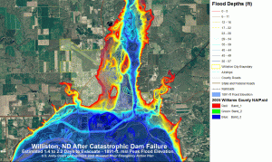
 Directions Magazine recently published “Emergency Preparedness and Response Planning for Catastrophic Dam Failure” by Jacquelin J. Stenehjem and Dr. Peter G. Oduor. Stenehjem participated in a National Council for Geographic Education training initiative, which the authors described in the article.
The growth of geospatial technology would be even greater if more well-trained workers were available. Many industries and agencies cannot fill open positions, even in this time of high unemployment. The Integrated Geospatial Education and Technology Training (iGETT) project, funded by the National Science Foundation with a 2012 grant to the National Council for Geographic Education, was developed to address the growing workforce need for geospatially-trained employees able to use remote sensing and geographic information systems (GIS).
The study focused on Williston, North Dakota, which is downstream from the U.S. Army Corps of Engineers-operated Fort Peck Dam. According to the article, the dam creates the fifth-largest reservoir in the United States. Stenehjem and Oduor demonstrate how remote sensing and geographic information systems can be valuable tools to aid communities in preparing for and responding to disasters.
